The eclipse track passes over the northern portion of the archipelago, with a center line duration of 3m 59s and a Sun altitude of 69°. Unfortunately, the center line misses all opportunities to make landfall. The island closest to the center line is Isla Pinta, a small volcanic peak protruding 750 meters above the waves. The island is uninhabited, though not always unoccupied. It is the offspring of two volcanoes, one old and worn, the other newer, but no eruption has been recorded on the island. Access is difficult, usually by chartered boat from the settlements of the larger islands to the south. Depending on the state of the sea, landing on Pinta may be wet, and equipment should be well protected. A licensed guide is required.
Several other islands also fall within the eclipse track, primarily the northern tip of the largest island, Isla Isabela, a small piece of Isla Fernandina, and Isla Marchena. All of the locations lying under the eclipse track are zoned for scientific use, a designation described by Constance (1995) as having "no possible access to the casual visitor with no specialized interest." Presumably the eclipse would constitute such a specialized interest. But in order to facilitate compliance with zoning regulations, eclipse travelers who wish to view from the Galápagos are likely best advised to travel as part of an organized group, or arrive early to arrange charters and permission to travel into the umbral zone.
Weather on the Galápagos is dictated by the winds and ocean currents, but this simple relationship is complicated by the archipelago's location at the confluence of two currents and two wind streams, so that the controlling forces change from season to season. Oceanic influences vary between the cool Humboldt Current from the coast of Peru, and the warmer Panama Flow which arrives from the northeast. Winds blow steadily from the southeast quadrant 67% of the time, but the islands lie only a short distance south of the Intertropical Convergence Zone (ICZ), a region of enhanced convective cloudiness caused by the collision of northerly winds from the northern hemisphere and southerlies from the south.
During February the ICZ is closest to the islands, and the wettest season is in full sway (the peak is in March). Observations at Puerto Baquerizo on Isla Cristobal show rainfall on nearly a third of the days of February (Table 24). Fortunately, February is also one of the sunniest months, with an average of 7 1/2 hours of sunshine brightening each day at Puerto Baquerizo and Darwin Station (at Puerto Ayora on Isla Santa Cruz). This contradiction between sunshine and precipitation is caused by the nature of the clouds, which tend to be convective, bringing brief periods of heavy showers between generous doses of sunshine. In fact Puerto Baquerizo is illuminated by 63% of the maximum sunshine amount possible, a number which also closely describes the probability of seeing the eclipse. Some minor adjustment in this probability is required for the time of day of the eclipse (likely a small increase), the location of the track (a slight downward adjustment for the more northerly islands) and the fact that "percent of possible sunshine" is calculated assuming a flat horizon with no refraction.
Convective buildups tend to come in the afternoon, promoted by upslope winds on the south and east sides of the islands. This suggests that the best eclipse sites will lie in the lee of the peaks, generally on the north and west sides. There is no guarantee here however, as cloud tops from the upwind side are easily blown downwind over the eclipse site and the weather may turn grey rather quickly if the day is particularly unstable. In fact the complicated wind flow over and around the volcanic terrain may bring showers at any location wherever two flows combine. The presence and dominance of cacti among the local vegetation will quickly identify the drier slopes and the most promising eclipse sites.
Mobility would be an advantage, but is probably not a viable option in view of the difficult terrain and lack of roads. Eclipse viewing from sea may offer a little more mobility, and a spot in the lee of the land will bring smaller waves than the one meter seas which are found in nearby open waters (Figure 16).
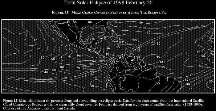
Satellite-derived cloud statistics (Figure 15) show that the mean cloud cover over the islands is a respectable 45%. This figure is an average over a 5° latitude by 5° longitude box, and includes a substantial area of ocean, thus giving a relatively coarse measurement of the highly variable cloudiness over the islands. While this is less illuminating than sunshine measurements from the ground, it has the advantage of making statistics more comparable from country to country, since it is determined in the same fashion at each location on the globe. Figure 15 and Table 24 indicate that sites in the Galápagos, though relatively sunny, are not as good as those over northern South America.