By October the Sun is well into its southerly winter decline and the Asian land mass is cooling rapidly during the longer nights. The southerly monsoon weakens, and a large anticyclone develops over Tibet and Siberia. The southerlies retreat, to be replaced by a dryer and cooler northerly outflow which arrives after descending the slopes of the Himalayan massif.
The retreat of the southeast monsoon and its replacement by the northerly monsoon begins in September in northern Pakistan and progresses steadily eastward across India through October. By eclipse time, the southern monsoon has usually been pushed into the Bay of Bengal, past Calcutta, and the entire eclipse path is immersed in the drier air flow. The dryness in the air and its origin over the Himalayas also brings cleaner skies for the eclipse.
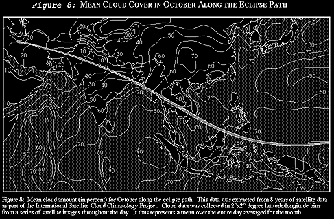
Across Pakistan and northwestern India, where the northern monsoon has been underway for over a month, mean cloud cover (from satellite observations) falls below 10 percent (Figure 8). Only the interior of the Sahara Desert has less cloudiness in October, and there are few eclipse sites that will ever have better weather prospects than the Great Indian Desert along the Pakistan border.
Surface climatological observations from stations through Pakistan and India show the same pattern of cloudiness (Table 16) as that revealed by the satellites. At Quetta and Jacobabad in Pakistan, mornings are sunny on 25 to 28 days of the month (other stations in Table 16 have too short a period of record to be reliable). This sunny record continues across northwest India, past Delhi and Agra, before declining beyond Allahabad toward Calcutta. Figure 10 shows that mean daily sunshine ranges between 9 and 10 hours over northwest India (out of about 11 possible), and then declines sharply to 7 hours at Calcutta. This pattern is also evident in the October statistics in Table 16.
Since these measurements in the figures and tables are gathered for the whole month of October, and the eclipse occurs close to the end of the month, the numbers favor those areas in the northwest which have been sunny for most or all of the 31 days. The cloudy southwest monsoon tends to withdraw from the Calcutta area during the latter half of October, so statistics for the city represent conditions which are partly characterized by the south monsoon and partly by the north. Thus, Calcutta will appear to be too cloudy in the statistics because of its late change to the northwest monsoon. The November figures might provide a better idea of the cloud prospects.
November sunshine statistics, which represent conditions entirely within the northwest monsoon season, show that sunshine in the Calcutta area increases to about 8.5 hours per day, while northwest India declines slightly to 9.5 hours. Thus the difference between the Calcutta area and the Delhi area at the end of October is not as large as the tables and figures indicate. Sunshine hours are probably about 15 percent higher in the northwest of India than along the Bay of Bengal. Of course all of this depends on the southwest monsoon having left the Calcutta area by eclipse time, a likely but not certain event.
Those in quest of the longest possible eclipse, without sacrificing too much of the good weather, might prefer the Calcutta area to Delhi and Agra. In the latter cities the eclipse duration is less than a minute; a site near Calcutta will see over 20 seconds more of totality. But monsoons are notoriously fickle creatures, and the eclipse date is barely a week after the normal withdrawal of the southerly monsoon at Calcutta. Observers who wish to take a position near the Bay of Bengal should rely on local weather reports and the 1995 status of the northwest monsoon to adjust their viewing plans.
At the infrequent times (15 to 25%) when the path through India is cloudy, the clouds come mostly from high level disturbances caught in the upper atmospheric winds. During summer months, the jet stream resides on the north side of the Himalayas carrying disturbances across Tibet and China. In October, as the continent cools, the jet makes a sudden shift southward, moving to the equatorial side of the mountains. Disturbances which were formerly carried into Tibet now move across northern Pakistan, India and Southeast Asia. Each of these can bring greater or lesser amounts of cloud according to their intensity.
These westerly disturbances are characterized by low pressure systems which move over northern Pakistan and head east northeastward into India. There are about seven or eight of these a month at their peak in January, but there are far fewer in October. The abundance of sunshine provides ample evidence that these systems are not particularly common in the fall.
Morning fog patches are rare across northern India, but increase in frequency toward the coast at Calcutta. Thunderstorms, mostly an afternoon phenomenon, are also more common toward Calcutta. Dust storms are an occasional hazard near the Pakistan border, but rare or unknown elsewhere. Since the northwest monsoon is in its early stages, winds are generally light everywhere and dust is most likely to be raised by the occasional thunderstorm or front.
The Bay of Bengal is famous for its cyclonic storms which occasionally strike the low lying coast of Bangladesh with great loss of life. These storms are not as common as their newspaper reputation would suggest, occurring with a frequency of less than once per month in October. About 30% grow to become severe storms with winds in excess of 90 km/h. Their normal path is to follow the east coast of India, curving to move inland across Bangladesh or northern Myanmar. However, a substantial fraction are not content to follow the common path, and instead head northwestward past Calcutta and into the center of the Indian sub-continent. While they weaken rapidly once they leave their ocean source, the extensive cloudiness thrown up by these storms has the potential to affect eclipse observing as far west as Allahabad, or even a little beyond. Similar cyclonic storms develop in the Arabian Sea, but are very unlikely to reach the eclipse track south of Delhi.