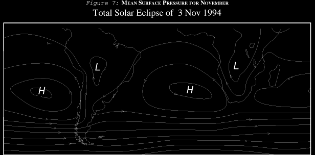
Weather is a product of winds and moisture. During this eclipse, the winds are controlled by two large oceanic high pressure systems or anticyclones (Figure 7). One of these lies west of Chile. The other is found off the coast of South Africa in the South Atlantic. These highs are permanent residents of the mid-ocean. Though they wax and wane with each passing disturbance, they never disappear completely.
A weaker continental low lying east of the Andes over Brazil divides the two highs. This low is created by warmer temperatures over the land, and is easily displaced by stronger but more transient weather systems that approach from the Atlantic. Because of the low, the weather across the eastern part of South America is more variable than that west of the Andes. The Pacific high and the Brazilian low regulate the weather over the land portion of this eclipse. The Atlantic high, lying closer to the African coast, has little influence over South America, but is the dominating system over the Atlantic portion of track.
In the southern hemisphere, winds circulate in a counterclockwise direction around the high pressure cells. On the Pacific side this brings a stubborn southerly wind onto the Peruvian coast. This wind is further strengthened by local sea breezes that build the largest sand dunes in the world. Sea breezes are onshore winds caused by the heating of the land along the coast. The heated air rises upward and cooler ocean air then moves inland to replace it.
The influence of the highs extends beyond directing wind flow. Air inside anticyclones descends from higher levels in the atmosphere. Air which is descending is warmed and dried. At the ocean surface is the cold Peruvian Current, bringing water northward from the sub polar regions off Antarctica. Warm air aloft and cool temperatures below combine to create a temperature inversion. The marine inversion off the Peruvian coast is very similar to its cousin off the coast of California. Both are very persistent.
Inversions are stable phenomena because cold air is heavy and sinks to the bottom of the atmosphere, resisting mixing with warmer layers above. They are of serious concern because marine inversions also collect water vapor from the ocean surface and become very cloudy. The water vapor is trapped, unable to mix with drier parts of the atmosphere above. The cloud isn't very deep, usually no more than about 900 meters (though occasionally up to 1500), but it is very resistant to clearing. In the air above the inversion, brilliant sunshine is the rule. Because the marine cloud is so shallow, it contains too little moisture to bring rain. What moisture is available comes from a persistent drizzle or a heavy morning dew that feeds specially adapted plants. Not much precipitation accumulates, resulting in a climatology that is both cloudy and dry. When it does rain along the Peruvian coast, it usually falls on the slopes of the Andes above the inversion.
About every three to seven years a phenomenon known as El Niño develops along the Peruvian coast. This is a complex oscillation in the weather patterns across the equatorial Pacific which reverses the normal climatology of the tropics when ocean currents warm and trade winds weaken. During El Niño years, the coasts of Ecuador and northern Peru typically become very wet and cloudy while droughts develop over southern Peru. An El Niño began in late 1991 and weakened in the summer of 1992. It was an unusual El Niño and did not completely fit the weather patterns which usually come with this oscillation. Its demise was also ambiguous and there were signs that the pattern was lingering into the spring of 1993. Since the El Niño occurred in 1991-92 and possibly into 1993, it would be unusual for another to develop in time for the November 1994 eclipse. Most likely normal weather and cloud patterns will prevail.
East of the Andes, the low pressure system that resides over Brazil draws air inland from the Atlantic Ocean. Air flow from the Pacific is blocked by the mountains. Storms and disturbances approach from the east. November is late spring in the southern hemisphere, comparable to May in the north. Summer weather patterns are not fully established, but the winter is gone, taking most of the storms and blustery weather. The eclipse takes place during a time of transition, but the weather may be quite distinctive for the season, and not just an average of the summer and winter patterns. In particular, November is the sunniest month over some parts of the eclipse track.
Above the surface, upper level winds blow mostly from the west except in Peru where they are more variable and occasionally from eastward. Because they are blowing out of the Pacific anticyclone, these upper westerlies are usually dry and cloud-free. Occasional weak disturbances will bring scattered showers and thundershowers to the Pacific side of the Andes, but these are much more likely on the other side of the mountain range, in eastern Bolivia.
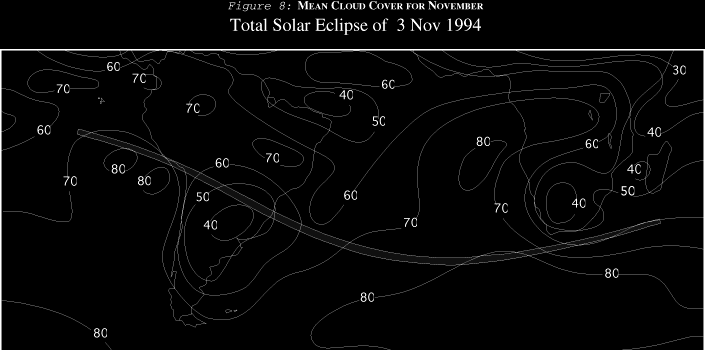
Figure 8 shows the large scale pattern of the cloud cover along the eclipse track. This chart was constructed from 10 years of satellite data analyzed by Russian researchers[9] at St. Petersburg (once Leningrad) University. To calculate the mean amount of cloud, the Earth was divided into large blocks of latitude and longitude. By averaging over a large area, the details of the cloudiness have been lost. In particular, Figure 8 gives a poor representation of cloud patterns over the mountains but those over eastern South America and the oceans are well shown. The most notable features are the high levels of cloudiness over the oceans and the sunnier conditions over Paraguay.
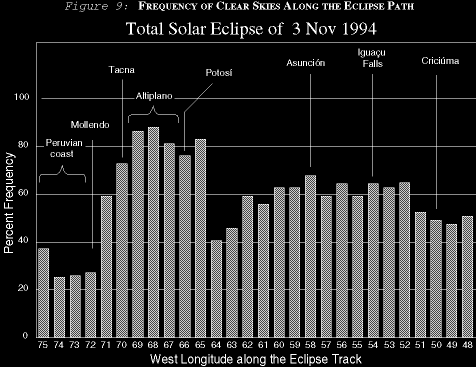
Figure 9 is a much more detailed look at cloud cover along the eclipse track. To make this graph, the eclipse track was plotted on daily satellite pictures taken near eclipse time during late October and most of November in 1991 and 1992. Cloud cover was then estimated at each degree of longitude along the track and assembled into the graph.
During the 1991-92 El Niño, abnormally wet weather covered parts of Argentina, Paraguay, Bolivia and Brazil from mid-November 1991 to January 1992. Since Figure 9 includes approximately one week of data from this period, the graph will show some biases which distort the relationship between the regions. In particular, Peru and the altiplano may be slightly sunnier than would otherwise be the case while more easterly sections probably show a little too much cloud. In November 1992, weather patterns seemed to have returned to those typical of non-El Niño years. Figure 9 should be used cautiously though the general relationship between regions is probably reliable. Figure 8 (based on a decade of satellite data) is more faithful to the large scale climatological cloud cover. Longer term statistics (which also include El Niño years) can be found in Table 14.