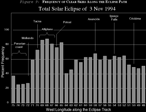
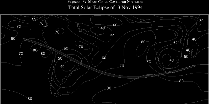
The Chaco is a northward extension of the foothill plains of Argentina into western Paraguay and eastern Bolivia. While the western portions are pretty cloudy, sunnier weather returns once the track crosses the Chaco and reaches Concepción. In Figure 9, the frequency of sunshine rebounds to about 70% for the two years studied. This is also reflected in Figure 8, which shows that large scale cloud cover reaches a minimum around Asunción during November. The region is visited by traveling weather disturbances that bring cold fronts from the south into contact with the moist air masses from the northeast. Extensive cloudiness and a catalogue of cloud types comes with these disturbances. These larger weather systems can usually be forecast well in advance (at least as easily as in North America!) and a well-planned eclipse expedition will be able to respond several days ahead. Most large disturbances have thinner spots and holes where mobile observers can gather. This is not an unfailing rule, as some satellite pictures in 1991 and 1992 showed the entire eclipse track covered in cloud from the Chaco to the Atlantic! When the fronts are far to the south, unorganized afternoon cloudiness and thundershowers may build. These usually start well after the appointed time of the shadow passage, leaving the mornings with brighter prospects.
Figure 9 suggests that no particular direction is favored in central and eastern Paraguay and in Argentina. The large scale weather patterns affect them all quite equally. Table 14 is a little more ambiguous since a few sites (Villarrica in particular) claim a very high frequency of clear skies. These conflict with the climatology of the area and are probably due to a very short period of record or erroneous data collection. For a general look at the prospects of the region, the statistics for Asunción are best since it has the longest record of any in the country.
The best strategy to handle weather in Paraguay and Argentina is to obtain forecasts several days in advance and have several widely dispersed sites available. The middle of the track can be reached on good highways by traveling northwest, north and east out of Asunción, and west or south out of Foz do Iguaçú (Iguassu Falls). While all three could be cloudy, chances are one will offer better prospects than the others. Remember that weather systems can be very large in this region, and considerable travel might be needed to find sunny skies.