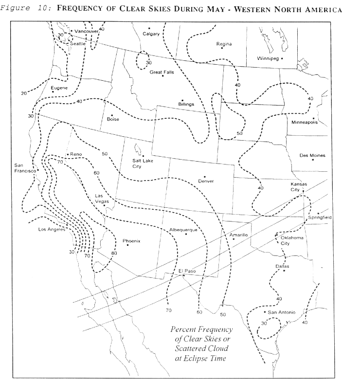
As the eclipse track moves northeastward, it encounters higher latitude weather systems where cloudiness increases steadily. Figures 10 and 11 show the frequency of clear skies (less than 1/3 cloud cover) in May for the U. S. and Canada. Excellent weather greets the umbra as it enters the U. S.. Discouraging statistics bid it farewell over the Atlantic, the Azores and Africa. Even under conditions of scattered cloudiness (<50% sky coverage), the annular eclipse should be visible. Based on climatology only, New Mexico, southeast Arizona and El Paso are the best destinations. May 1992 satellite photos show that the El Paso area had favorable conditions at eclipse time on 21 days. Areas in Mexico faired even better.
The Gulf of Mexico supplies most of the moisture which fuels the weather systems of spring. In May, low level winds have turned to the south across much of the Gulf coast and Great Plains. Warm humid air floods northward to mark the beginning of summer. Thunderstorms often erupt across the States as weather disturbances and frontal systems collide with the humid air. The westward flow of Gulf air is blocked by the Rocky Mountain chain, and is re-directed into Oklahoma, Kansas, Missouri, and eastward to envelop the lower Great Lakes. The Appalachians block the flow to some extent, but the Atlantic Ocean, another moisture source, is ready to fill in when winds turn easterly.
The western edge of this giant atmospheric river lies very nearly along the eclipse track. Upper level westerlies carry high altitude disturbances over the humid air where they trigger the giant thunderstorms which characterize springtime American weather. Afterwards the westerlies push the humidity and cloud eastward for a short time, returning dry and sunny skies to the Plains for a few days. Inexorably, southerly flow begins again and the Gulf moisture returns to fuel yet another disturbance.
Over northern sections, along the Great Lakes, New England States and over southern Canada, occasional polar air masses make a sortie southward. Marked by low pressure systems, and strong warm and cold fronts, these systems come with extensive cloud shields and usually rain. The lows pause briefly along the west slopes of the Appalachians, gathering resources to push over the peaks and into New England. Its a cloudy area, because of the lingering polar lows, the mountains, the Atlantic Ocean and the Gulf moisture. Figure 11 shows that the frequency of good eclipse weather drops below 30% from West Virginia to Maine, and again over Nova Scotia. The cloudiest area of all lies over New Hampshire and Vermont.
Since thunderstorms usually form in the afternoon and evening, a morning eclipse will escape the greatest threat of heavy weather. Cloud cover also increases during the day, reaching a maximum in the late afternoon. Figures 10 and 11 are drawn from morning cloud statistics, better reflecting the climatology that applies to the eclipse. Humid Gulf air masses also bring hazy polluted skies to areas east of the Mississippi. However, it's not likely to be much of a problem for an annular eclipse.
In western regions [Texas and Oklahoma], the dust storm season ends by May 10. Strong surface winds may whip up the dirt in small areas downwind from bare fields, but growing crops will bind the soil and tame more widespread storms. May is the month for tornadoes and hail across much of the mid west and through the Great Lakes, but is still a month or more away from the start of the hurricane season.