The limits of the Moon's penumbral shadow define the region of visibility of the partial eclipse. This saddle shaped region often covers more than half of Earth's daylight hemisphere and consists of several distinct zones or limits. At the northern and/or southern boundaries lie the limits of the penumbra's path. Partial eclipses have only one of these limits, as do central eclipses when the shadow axis falls no closer than about 0.45 radii from Earth's center. Great loops at the western and eastern extremes of the penumbra's path identify the areas where the eclipse begins/ends at sunrise and sunset, respectively. If the penumbra has both a northern and southern limit, the rising and setting curves form two separate, closed loops. Otherwise, the curves are connected in a distorted figure eight. Bisecting the 'eclipse begins/ends at sunrise and sunset' loops is the curve of maximum eclipse at sunrise (western loop) and sunset (eastern loop). The exterior tangency points P1 and P4 mark the coordinates where the penumbral shadow first contacts (partial eclipse begins) and last contacts (partial eclipse ends) Earth's surface. The path of the umbral shadow bisects the penumbral path from west to east and is shaded dark gray.
A curve of maximum eclipse is the locus of all points where the eclipse is at maximum at a given time. They are plotted at each half hour Universal Time (UT), and generally run from northern to southern penumbral limits, or from the maximum eclipse at sunrise or sunset curves to one of the limits. The outline of the umbral shadow is plotted every ten minutes in UT. Curves of constant eclipse magnitude delineate the locus of all points where the magnitude at maximum eclipse is constant. These curves run exclusively between the curves of maximum eclipse at sunrise and sunset. Furthermore, they are quasi- parallel to the northern/southern penumbral limits and the umbral paths of central eclipses. Northern and southern limits of the penumbra may be thought of as curves of constant magnitude of 0%, while adjacent curves are for magnitudes of 20%, 40%, 60% and 80%. The northern and southern limits of the path of total eclipse are curves of constant magnitude of 100%.
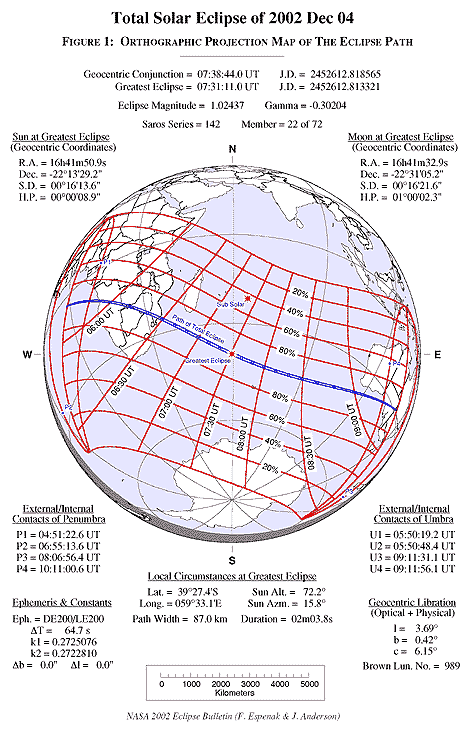
At the top of Figure 1, the Universal Time of geocentric conjunction between the Moon and Sun is given followed by the instant of greatest eclipse. The eclipse magnitude is given for greatest eclipse. For central eclipses (both total and annular), it is equivalent to the geocentric ratio of diameters of the Moon and Sun. Gamma is the minimum distance of the Moon's shadow axis from Earth's center in units of equatorial Earth radii. The shadow axis passes south of Earth's geocenter for negative values of Gamma. Finally, the Saros series number of the eclipse is given along with its relative sequence in the series.