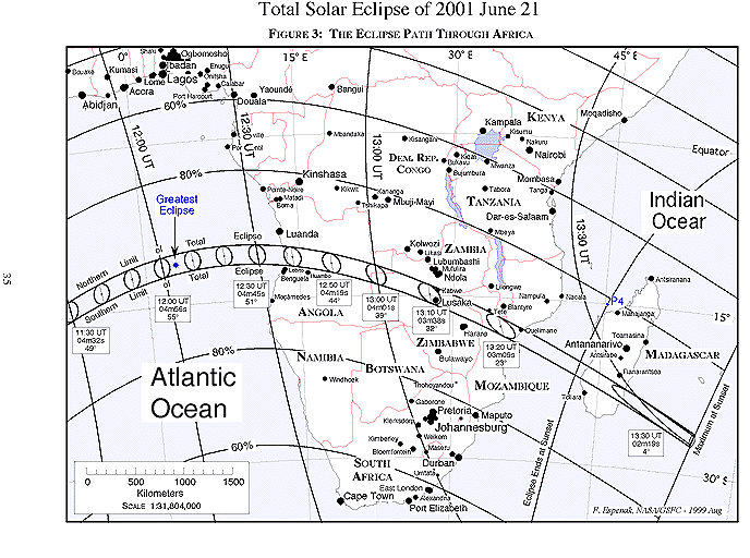
The instant of greatest eclipse occurs at 12:03:41 UT when the axis of the Moon's shadow passes closest to the center of Earth (gamma = -0.570). The length of totality reaches its maximum duration of 4 minutes 56 seconds, the Sun's altitude is 55°, the path width is 200 kilometers and the umbra's velocity is 0.554 km/s. Unfortunately, these most favorable circumstances occur at sea some 1100 kilometers west of equatorial Africa's South Atlantic coastline (Figure 3).
Another half hour will elapse before the umbra reaches southern Africa. During this period, the duration and path width will slowly wane as the curvature of Earth carries the projected eclipse path away from the Moon. As a result, the tapering shadow cone will present a progressively narrower cross section to Earth's surface along the path of totality. Nevertheless, the 2001 total solar eclipse is over twice as long as the last total eclipse in 1999 at all corresponding positions along the path (i.e. - sunrise, transit, sunset).
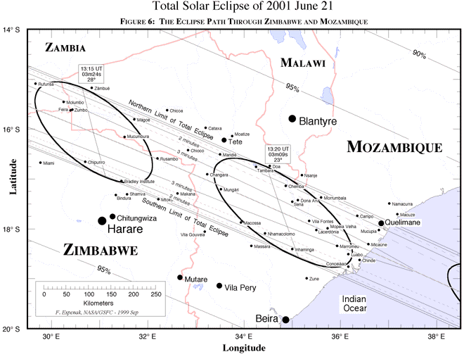
Landfall finally occurs along the Atlantic coast of Angola at 12:36 UT (Figure 4). The center line duration is 4 minutes 36 seconds, the path width is 193 kilometers and the Sun's altitude is 49°. Traveling with a ground speed of 0.63 km/s, the umbra swiftly moves eastward through the civil war torn nation. Although the weather prospects are excellent, Angola's political strife makes it a dangerous place for eclipse observers. By 12:57 UT, the shadow reaches the western border of Zambia where totality lasts a maximum of 4 minutes 6 seconds (Figure 5). The umbra's path is now directed to the east-southeast as it heads towards the nation's capitol city. Lying about 35 km south of the center line, Lusaka enjoys a total eclipse lasting a respectable 3 minutes 14 seconds. Further to the north, the center line duration is 3 minutes 35 seconds and the Sun's altitude is 31°. Quickly crossing the Zambezi River, the path continues into Zimbabwe and Mozambique. The center line runs near the border between these two nations for several hundred kilometers. Zimbabwe's capitol city of Harare lies just 100 km south of the path, so its citizens will witness a partial eclipse of magnitude 0.976 (Figure 6). As the umbra leaves Zambia, it lies wholly within Mozambique for a minute before its leading edge reaches the shore of the Indian Ocean (~13:20 UT). At nearly the same time, its northern edge just skirts the southern border of Malawi. The center line duration is now 3 minutes 09 seconds as the Sun's altitude drops to 23°. The shadow's speed has increased to 1.7 km/s as it begins to leave the continent for the open waters of the Indian Ocean.
One last major landfall remains as the umbra races over southern Madagascar (Figure 7). The eclipse occurs quite late in the day with the Sun just 11° above the western horizon. The central duration now stands at 2 minutes 25 seconds (13:28 UT) as the shadow's long elliptical projection stretches across the entire east- west breadth of the island. Continuing into the Indian Ocean, the umbra leaves Earth's surface (13:31:33 UT) as the path ends. Over the course of 2 hours and 54 minutes, the Moon's umbra travels along a path approximately 12,000 kilometers long and covering 0.3% of Earth's surface area.