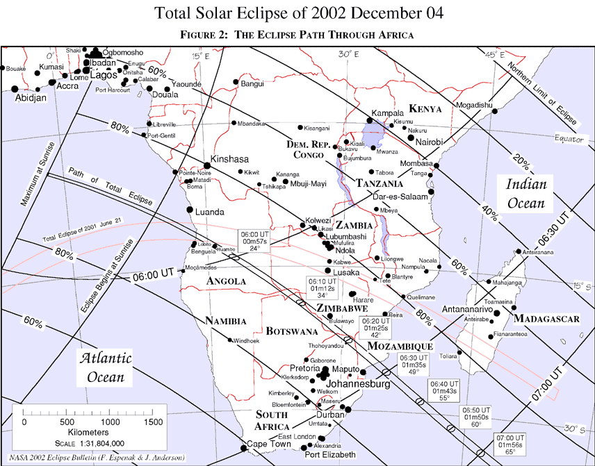
Equidistant-conic Projection Map of the Eclipse Path
Figures 2, 3,
4 (covering Africa), 12 and
13 (covering Australia) are maps using an equidistant
conic projection chosen to minimize distortion, and which isolate the African and Australian portions of the
umbral path. Curves of maximum eclipse and constant eclipse magnitude are plotted and labeled at intervals
ranging from one to ten minutes, depending on the map scale and umbral shadow velocity. A linear scale is
included for estimating approximate distances (kilometers). Within the northern and southern limits of the
path of totality, the outline of the umbral shadow is plotted at intervals of ten minutes or less. The duration
of totality (minutes and seconds) and the Sun's altitude correspond to the local circumstances on the center
line at each shadow position.
The scales used in the maps in these figures are as follows:
The positions of larger cities and metropolitan areas in and near the umbral path are depicted as black dots.
The size of each city is logarithmically proportional to its population using 1990 census data (Rand
McNally, 1991). City data from a geographic data base of over 90,000 positions are plotted to give as many
locations as possible in the path of totality. Local circumstances have been calculated for many of these
positions and can be found in Tables 11 through 18.
 Next section
 Table of Contents