Zimbabwe has a well-developed tourist infrastructure and accommodation for a large number of people. Mount Darwin and Centenary, both within the path and well connected to Harare by road, are likely to prove popular setting-off points for the center line. According to the Michelin map, good roads lead north from both of these communities, reaching to within a few kilometers of the shadow axis. Geoffrey Carew of Carew Safaris (Harare) reports that "roads to the center line are good quality tar as far as Muzarabani and then reasonable dirt roads from there on."
There are numerous safari camps across northern Zimbabwe, some very close to or even on the centerline, which will allow a relaxing and very exotic wait for the MoonŐs shadow. Most of these camps can hold only a small number of people, but at least some have plans to make accommodation for larger groups for the eclipse. In particular, the Mavuradonha Wilderness, a game reserve of rugged uplands on the Escarpment, may prove to be an irresistible destination for groups of eclipse watchers who might enjoy the African outdoor experience. Carew Safaris is planning a riding safari to view the eclipse at 1660 m from Makura Mountain, an altitude that should improve the weather prospects even further.
The path enters Zimbabwe just north of Mana Pools National Park. The Park is designed mostly for canoe or walking safaris. According to Trish Berry of the Zambezi Safari and Travel Company (Kariba), Mana Park "is not usually an area that one can drive through independently" as specific licenses and professional guides are required for a visit. There is a minimum of nine persons per guide. Visitors in this area will have to go extra trouble to reach the centerline and scrounge the last few seconds out of totality. This may be a location where it is better to sacrifice the additional time in exchange for a magnificent safari setting, or become more adventuresome and take a canoe trip down the Zambezi to maximum eclipse.
Perhaps the greatest limitation to Zimbabwean sites is the lack of convenient routes for movement to sunnier locations should the selected site turn suddenly cloudy, as all roads tend to run across rather than along the track. The easiest highway track to the eclipse lies on the route from Harare to Tete (a distance of 238 kilometers to the centerline). The actual centerline lies slightly inside Mozambique, just beyond the border crossing at Nyamapanda, but the loss in the duration of totality from the Zimbabwean side is of the order of only a few seconds.
For the most part, the weather through northern Zimbabwe is similar to that in eastern Zambia. Cloudiness is only slightly higher, and the percent of possible sunshine correspondingly lower, by a few percentage points. June precipitation is higher than in Zambia, but barely so (less than 1 mm at Mount Darwin), at least in the vicinity of the shadow track. Because the Zimbabwean half of the track lies on the heights of the Zambezi escarpment, it escapes the larger part of the cloud that traverses the valley below and which gives a distinctly higher cloud cover to the Mozambican half of the track.
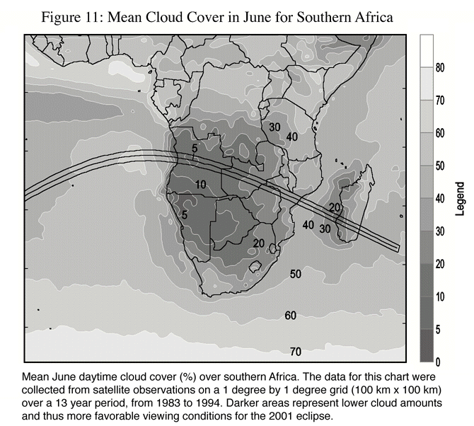
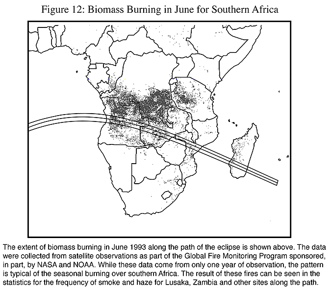
From a climatological point of view, the best sites in Zimbabwe will be those in the west, close to the Zambia border. The general trend to increasing cloudiness as the track moves eastward is reflected in the satellite measurements in Figure 11 and the statistics in Table 17. In the west near the Zambia border, Kariba and Karoi, both just outside the path of totality, show 82 and 76% of possible sunshine respectively. Slightly farther along the track, Mount Darwin reports 74% of the maximum possible, while Tete (Mozambique), much lower in the valley and farther east, reports a meager 58%. These gradual trends in cloudiness are confirmed by the behavior of the cloud patterns in 1998 graphed in Figure 13. The high levels of cloudiness at Tete do not recommend a location near Nyamapanda unless a favorable forecast for the area can be obtained a day or two ahead of time for the area.
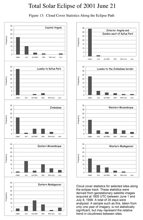
As in Zambia, temperatures in Zimbabwe are pleasant and humidity is low, except during a guti. The frequency of hazy skies is considerably lower than in Zambia, evidently because the extent of biomass burning is lower than farther west (Figure 12).