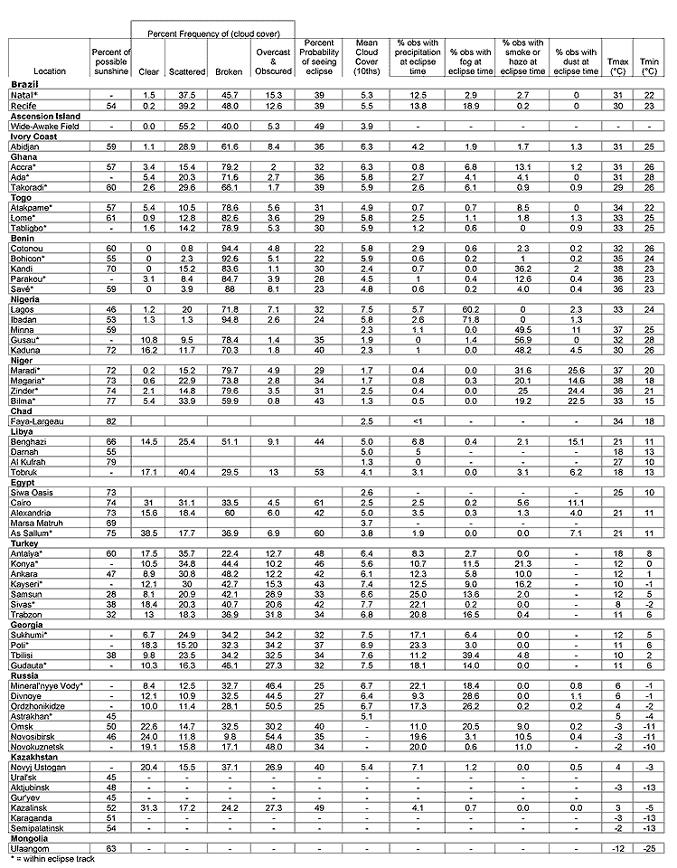
The eclipse path begins in the tropical climate of northeastern Brazil, south of the Intertropical Convergence Zone (ITCZ) where the southeast trade winds bring a generous humidity onto the land (Figure 21). The ITCZ is a cloudy, unstable and wet region where winds from the southern and Northern Hemispheres converge, forming the Earth's "weather equator." Leaving Brazil, the shadow path curves slowly northward across the Atlantic and then turns more sharply as it reaches the African coast, crossing to the north side of the ITCZ in northern Nigeria and into a sharply drier climate controlled by winds from the Sahara Desert. Maximum eclipse is attained over the desert before the path moves across the Mediterranean coast and into the influence of the mobile highs and lows of the middle latitudes.
Leaving Turkey, the shadow moves gradually back into winter as it crosses the Black Sea and Georgia and then heads into Kazakhstan. The Siberian anticyclone, which is a large and semi-permanent high-pressure system, traps winter over the middle of Asia well past March and temperatures fall steadily as the track moves through Kazakhstan. The eclipse comes to its sunset termination in the center of the Siberian anticyclone in Mongolia where the cold temperatures bring a frequency of sunny skies that rivals those in southern Turkey.
Cloudiness varies in concert with the diverse weather zones. Along the ITCZ, skies have a high frequency of heavy cloudiness as the wind flow from the two hemispheres converges and forces the tropical air to rise, a surefire recipe for cloud and rain. In late March, the Sun has crossed the equator on its annual trip northward, and the additional heating of the atmosphere brought on by the overhead Sun brings the spring rainy season to equatorial latitudes.
Cloudy conditions are especially prevalent over the African coast in Ghana where moist southerly winds blow onto land with a rising terrain. The air is forced to rise by the landscape, further magnifying the cloudy impact of the ITCZ. Most of the cloud is convective in nature - showers and thundershowers - which usually means that there is sunnier weather nearby and the frequency of completely overcast skies is relatively low (Table 21).
Over northern Nigeria, the winds flowing into the ITCZ originate over the Sahara Desert and have no moisture to contribute to cloud building. There is an abrupt change to a sunny climate in this area, but the winds are laden with desert dust and sand, which puts a reddish haze into the sky. Fortunately, the impact of the dust-laden skies on the eclipse is likely to be one of muting its visibility rather than hiding it completely. Eclipse maximum is reached over the Sahara, just inside Libya, where the frequency of sunny skies is the highest in the world.
Pressing northward, the shadow crosses the Mediterranean coast and enters the mid-latitudes, where weather comes from a never-ending procession of high and low pressure systems - the signature of springtime in the Northern Hemisphere. During March and April, low-pressure systems form preferentially on the east side of the Atlas Mountains in Algeria and travel eastward along the coast of North Africa - either just inland or a short distance offshore. These lows are poor rainfall producers but make the season a windy one along the coast, with occasional dust storms, some of epic proportions that have given rise to adventure stories and legends. The weather that accompanies these lows is more variable than elsewhere along the African part of the track: hot, dry, and dusty southerlies as the lows approach, cool and cloudy northerlies as they depart, and a certain amount of misbehavior while they are nearby, mostly from cold fronts and occasional thunderstorms.
On the north side of the Mediterranean, Turkey and Greece have their own set of Mediterranean lows in spring. The Ionic Sea southwest of the Greek mainland tends to be a holding zone for lows that come from the west and northwest. After regrouping in this area, the lows continue their journey into Asia, heading either northeastward into the Black Sea or eastward to Cyprus and beyond. Both tracks will plague the eclipse path, either along the Black Sea coasts, or near Antalya in southern Turkey. European lows also have influence in the area, especially the farther north one goes along the eclipse path, and so there is a steady increase in cloudiness from Mediterranean Turkey to Georgia's Black Sea coast. The cloud cover is encouraged by the rough terrain throughout this region, which causes airmasses to rise and condense.
The high levels of cloudiness continue through the Russian Caucasus and western Kazakhstan, but once over the Ural Mountains and onto the steppes of central Asia, the Moon's shadow begins to encounter the sunnier skies and colder temperatures brought by the Siberian anticyclone. At its terminus, daily temperatures are cold enough to present some discomfort to the observer who might otherwise be rewarded with pristine skies and a glorious sunset.
In March and April, the ITCZ is at its most southerly position over Brazil (Figure 21), and thus, about as close as it can get to the eclipse path. A steady trade wind circulation blows from the southeast onto the land, which rises rather sharply into a tumble of hills and valleys around the cities of Recife and Natal. The coastline is bathed with a sultry airmass carried onshore by the light southeast winds from the warm Brazilian Current offshore. The immediate coastline is subject to daily sea breezes that reinforce the prevailing trade winds, but wind speeds usually drop to only a few kilometers per hour after penetrating a short distance inland. Winds above the surface also tend to blow from the east and so eclipse observers should keep an eye on the sunrise direction for incoming cloud and cloud-free holes, rather than the opposite hemisphere as is the case at higher latitudes.
Temperature and humidity are high in the Brazilian tropics and fog is a regular morning visitor. It is most common at sunrise but the actual frequency varies considerably from place to place along the coast. At Natal, fog is reported at 6 AM on only 1 day in 30 during March, but at Recife the frequency is more than 1 day in 6 (Table 21). Similar variations can be found all along the Atlantic coast and eclipse sites should be selected with advice from local experts. Inland locations do not seem to offer any advantage over those on the coast, but fog will tend to collect in valleys and at lower elevations, at least until the Sun begins to burn it off.
Eclipse sites can be chosen at higher elevations away from its influence, keeping in mind that the rising Sun will tend to lift the fog off the ground and blow it westward as a low cloud cover. Rising terrain that faces eastward into the prevailing wind will form low clouds much more readily than that with a downslope wind, and so eclipse sites on eastward facing slopes should be avoided. Unfortunately, adjusting sites according to the winds is not very helpful advice as winds are calm at 6 AM at Natal on over 50% of mornings in March.
Coastal Brazil is in the early stages of the summer rainy season in March with a corresponding paucity of sunshine. Recife is climatology records an average of 54% of the maximum possible sunshine for the month (Table 21). While the "percent of possible sunshine is the best measure of the probability of seeing the eclipse, cloud cover is slightly heavier in the morning than in the afternoon and so the sunshine percentage, which applies to the whole day, is probably slightly too generous a predictor for the eclipse hour. A simple calculation of the probability of seeing the eclipse based on cloud cover statistics is more pessimistic at 39%, but this statistic is strongly biased toward greater cloud amounts and should be used only to compare one station with another in the absence of sunshine data.
No single location stands out as the most favorable eclipse sites in Brazil. The best chances will likely go to a seaside location at a sites that is known to be relativey free of fog, either historically, or at least for the eclipse morning. Onshore breezes, if any, will tend to push the cloud inland a short distance and the flat Atlantic horizon will present a convenient view to the low eclipsed Sun. The coastal highway from Natal to Joao Pessoa will allow movement across the eclipse track to a sunnier location if the initial choice of site proves to be unfavorable.
West Africa - Côte d'Ivoire, Ghana, Benin, Togo, and Nigeria - are in the early stages of the spring rainy season in March. The ITCZ is moving northward and becoming more active as the northward-moving Sun brings warmer temperatures to the land. The climatological position of the ITCZ lies along the northern borders of Ghana, Benin and Togo, and across the northern third of Nigeria (Figure 21), but it is a mobile feature and oscillates back and forth from week to week. In any given year, there will be modest differences in the position and activity along the ITCZ, depending on the character of the season.
The rainy season begins in March in Abidan (Côte d'Ivoire and Cotonou (Benin) with a sharp increase in monthly rainfall and a corresponding rise in cloudiness. Both of these cities lie along the coast where they come under the early influence of the southeast winds blowing toward the ITCZ. Farther north, the onset of the rainy season is delayed until the ITCZ has passed to the north and the moist southwesterlies from the Atlantic reach the region. At Natitingou in the northern part of Benin, the rain does not arrive in force until April, although there is an increase in rainfall in March as the ITCZ approaches. Alas, the clouds arrive before the rainfall, and Natitingou has relatively poor viewing prospects for eclipse day with over 89% of observations reporting broken cloudiness on March mornings.
Accra has a noteworthy microclimate that gives less rainfall to the city and surrounding plains than other locations along the coast, but the drier weather does not seem to be accompanied by a matching increase in sunshine. Both the "percent of possible sunshine and "probability of seeing the eclipse" values in Table 21 are similar to measurements at other coastal cities such as Lom and Abidjan. North of Accra, the coastal plateau gives way to a rising landscape. It can logically be assumed that cloud cover will increase there as the prevailing winds are forced to rise, though there is scant evidence of this in the climatological record. Examination of Table 21 will show that the cloud conditions along the eclipse path and south of the ITCZ in this part of Africa are pretty uniform. The percentage of possible sunshine ranges from 55 - 65 percent, and the "probability of seeing the eclipse" (which can be thought of as a summary of the cloud statistics) ranges around 30%.
The low value of the "probability of seeing the eclipse" speaks of a large amount of thin cloudiness - thin enough to let the Sun register its signal on sunshine recorders, but thick enough for human observers to characterize it as broken or overcast. The "percent of possible sunshine" is also likely slightly pessimistic, as the mid-day has less cloudiness than either the morning or late afternoon, and so the percent of sunshine at the eclipse hour may be a few percentage points higher than the daily average.
High humidity brings a high incidence of fog in the morning hours. At Accra, about 16% of mornings come with fog, but observations close to the eclipse hour show that much of this has burned off and the frequency of foggy hours has declined to around 6%. Inland stations fare much more poorly, with 50% of morning hours in most locations in central Nigeria reported as foggy. Some particularly misty locations such as Ibadan (Nigeria) have a frequency of fog at sunrisethat exceeds 70%. Fog on eclipse morning is a danger signal, for the cooling associated with the approach of the lunar shadow is likely to result in the redevelopment of fog, especially in areas that experienced fog at dawn.
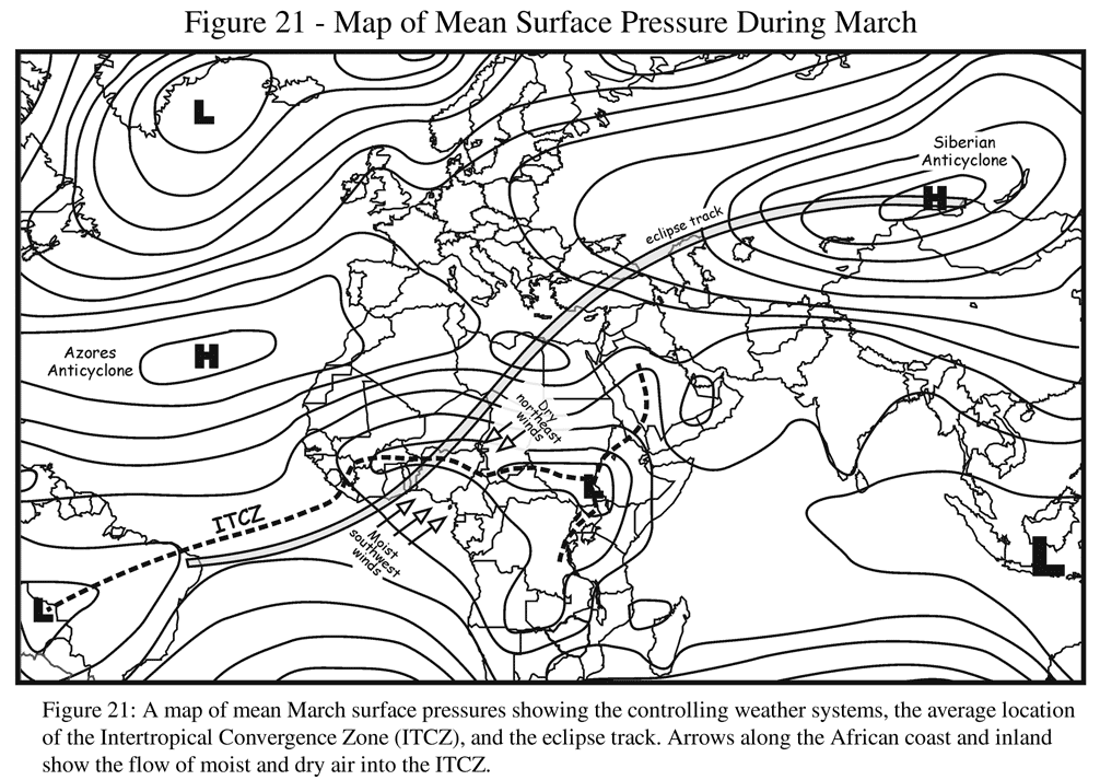
North of the ITCZ, the climatology is completely reversed. Winds flowing into the convergence zone from the north have the Sahara Desert as their source, with a sharply lower humidity. Rainfall is much lighter, cloudiness reduced, humidity tolerable, and eclipse prospects much brighter. Most of the benefit of the Saharan airmass isn't realized until the eclipse path crosses into Niger, but the northern half of Nigeria does see some improvement in cloudiness. This is particularly evident in Figure 22 where satellite measurements show a mean cloudiness of 60% along the coast, falling to under 20% where the track reaches the border with Niger. Table 21 also reflects this transition, with the percent of possible sunshine jumping from 55% at Bohicon in southern Benin, to 72% at Kaduna in northern Nigeria.
In a very few miles, the eclipse passes from the region with one of the poorest cloud records to one with the best. As noted above, the large amount of cloudiness recorded in Table 21 is a poor reflection of the actual weather, as it is biased by a high frequency of thin cloud. The satellite-based maps in Figure 22 are much less affected by this bias and are more reliable as a measure of eclipse chances. International observing standards for weather observations require that the cloud cover be reported according to the amount of sky covered, regardless of its transparency.
The Saharan air that arrives in West Africa (known locally as the harmattan ) brings evidence of its desert origin in the form of frequent reports of dust and haze. In northern Nigeria and southern Niger, the surface observations show a high frequency of haze (and smoke), typically on 50 or 60% of March mornings. Satellite observations of atmospheric transparency show that this region - that is, everywhere south of the Sahara - has an endemic haziness from high-altitude dust blown from the desert. Such haze, coupled with a high frequency of thin cirrus cloud, will make observation of the outer corona difficult.
Through Niger, Chad, the Sudan, Libya, and Egypt, at least as far as the Mediterranean coast, the eclipse path is completely immersed in the Sahara Desert. It is sunny, sandy and hot, and the occurrence of thin high cloudiness drops dramatically as the track reaches the Libyan border. Observation sites are sparse and not conveniently located, except for Bilma in Niger, which lies very near the central line. At Bilma, sunshine hours reach 77% of the maximum possible, and probably peak above 85% where the borders of Libya, Chad, and Niger come together. The frequency of completely clear skies rises from 5% in the Bilma area to about 55% in southern Libya. Satellite-based measurements show a mean cloudiness (Figure 22) of 10 - 20% in this area.
In spite of its location in the midst of the Sahara Desert, Bilma reports only half the haziness of northern Nigeria. The lower frequency of high-level haze is balanced by a correspondingly higher frequency of dust. Bilma lies closer to the source region in Chad where much of the Saharan dust originates, and so a smaller percentage of it has been lifted high into the atmosphere. Instead, the lower atmosphere is full of dust - sometime blowing violently right at the surface! The distinction between dust and haze in the meteorological observations is only a reflection of the depth of the atmosphere affected - both are a result of dust storms in the desert. Satellite observations occasionally trace the dust blowing off the Sahara all the way to the Caribbean.
In the northern Sahara, the main meteorological feature of spring is a series of low-pressure systems that form in Algeria and move eastward over land. These lows are known as khamsin depressions; they have an average frequency of three or four per month. The khamsin low is small and usually without precipitation, but carries high- and medium-level cloud and dust-laden air.
Very similar to the khamsin low is a Mediterranean depression that travels along the coast, usually just offshore. The two are different manifestations of similar weather systems - one is a desert system with no ready moisture supply, the other moves over the Mediterranean and has access to generous amounts of moist air. Because of winds associated with these two systems, the frequency of dust storms increases north of Jalu and peaks along the Mediterranean coast.
The actual incidence of low-visibility storms is relatively low. At Bilma (Niger), visibilities below 1mi (1.6km) occur at eclipse hour on a little over 5% of March days. Visibilities of 1/2 miles or less occur on just over 2% of March days. While these seem to reflect favorably on eclipse prospects, it should also be noted that more than 1/3 of March days report visibilities lower than 5 mi. In other words, serious dust storms are uncommon, but lesser amounts of blowing dust are ordinary events.
No data are available to assess visibility at Jalu (Libya), but the frequencies there are likely much better than at Bilma. Salloum (Egypt), which is regarded as one of the dustiest places on the coast, has a frequency of poor visibilities about 1/6 those at Bilma. In spite of the low incidence of serious sandstorms, eclipse observers should come prepared with protective coverings, for the ability of the dust and sand to infiltrate and damage cameras and other equipment is legendary.
The eclipse path traverses the north coast of Africa where the borders of Libya and Egypt meet the Mediterranean. This coastal region has a climate determined by a combination of desert influences and the weather brought by passing mid-latitude low-pressure systems that travel offshore. The south Mediterranean lows and the khamsin depressions that affect the inland desert are the first encounters with mid-latitude disturbances that are the hallmark of European springtime weather systems. They come with heavy cloud, cold and warm fronts, occasional precipitation, and plenty of dust-raising wind. Occasionally, these lows will develop through a deep layer of the atmosphere and become "cut-off" from the normal eastward flow of weather systems. If this should happen, poor weather will hang around for several days, cloud cover will be much thicker, and thundershowers with heavy rain may develop.
Typically, the approach of one of these lows will be heralded by gradually increasing high-level cloudiness and southeast winds. Temperatures will rise as warm air is drawn to the coast from the interior; as wind speeds increase above 30 km/h, blowing sand begins to reduce visibilities. These khamsin conditions cause the sky to adopt a yellowish veil and sand creeps into every crevice Extremely low humidities add to the discomfort. Thickening clouds and increasing winds, now turning to the south and southwest, will mark the arrival of the center of the low. The winds tap the source region of the sand and dust, and visibilities will decline perhaps to a kilometer or less.
As the low-pressure center departs eastward, a cold front sweeps across the coast and deep into the desert, often for several hundred kilometers. The front may carry only a light cloudiness or a line of thunderstorms with strong downdraft winds. The thunderstorm winds, which may gust to well over 100 km/h, can bring the most intense sandstorms with visibility falling to only a few tens of meters as sand penetrates every cranny and the Sun is obscured. Such intense storms, which are thankfully quite rare, but are the stuff of legend, are known by various names including haboob (in Egypt and the Sudan), ghibli (in Libya) or samoon (in Arabia). The most intense of these will last only a short while, until the thunderstorm winds have passed, but the less intense khamsin conditions can last for several days. There is an Arabic saying that five days in a khamsin wind is a sufficient excuse for murder.
With the passage of the cold front, winds will turn to the west and northwest and temperatures will fall sharply. Visibilities improve even though winds remain strong, as they no longer blow from the main source of the sand in the south. Cloudy skies will linger until the low is well away to the east. The cool air brought onto the land leaves a high-pressure system in the wake of the low, with clear skies and light winds. Most fortunately for the eclipse-chaser, this is the prevailing meteorological feature of the Egyptian coast in March (Figure 22).
Salloum (or As Salloum, or Salum) in Egypt or nearby sites in Libya are likely to be the primary destination for eclipse observers, so it is worthwhile to examine the climatological record in detail for this location. Salloum lies at the bottom of a semicircular bay on the Mediterranean coast, under the looming heights of the Libyan plateau a few kilometers to the west. The boundary with Libya lies on the heights about 15km distant and the border area would be an ideal observing site if permission can be obtained from the military authorities. Salloum has a high frequency of sunshine, with 75% of the maximum possible recorded in March (Table 21). Clear skies and skies with scattered cloud are observed on more than half of March days and precipitation averages only a few millimeters in the month. Observations reporting dust or sand are recorded on 7% of the hours at eclipse time (Table 21). Less than 1% of March observations recorded visibilities below 1mi (1.6km). A little over 6% of observations show a visibility below 5mi (8km). Temperatures are cool, with highs of 21°C and overnight lows of 11°C.
Cloud cover in Salloum comes almost entirely from the traveling khamsin lows and Mediterranean depressions. Such systems are relatively easy to see coming in satellite imagery, and can be timed by watching movement over several days or hours. The four-lane highway heading east from the community provides a convenient route to look for better skies, especially because most observers will travel to the path from locations such as Marsa Matruh, and will already be familiar with conditions en route.
The north Mediterranean region forms a distinct climatic unit, with its own series of low-pressure depressions in the winter and spring that move from west to east. The depressions have preferred basins for development, one of which lies southwest of Greece. about 40% of the lows that collect in this area travel eastward toward Cypress; the remainder move northeast into the Black Sea. In most cases, these Mediterranean lows are linked to disturbances over central Europe and the cloud cover can be very widespread.
The track of the more southerly lows leads to the south coast of Turkey, opposite Antalya where the lunar shadow comes onshore. In spring, these disturbances have lost much of their winter intensity and in late March, the winter rainy season is all but over. Approaching weather systems will bring moist southerly winds against the coast along the Gulf of Antalya (Pamphylia). It is a rugged coastline outline by the Taurus Mountains to the east of Antalya and the Bey Mountains to the northwest. Immediately east of the city is a flat coastal plain that extends 50 km inland and covers the eclipse path from the north limit to the central line. From the central line to the southern limit, the coastal plain is only about 20 km wide.
The topography along the Gulf of Antalya presents both opportunity and difficulty for eclipse expeditions. The high mountains that frame the coast will dry airmasses approaching from the west and north, while promoting additional cloudiness for those coming from the south as they ascend the terrain. The eclipse observer's best ally is the gentle slope of the coastal plain which has only a minor effect on cloud development. Antalya's southern location and the beneficial effects of the terrain make it one of the sunniest places in Turkey. The best measure of eclipse viewing chances, i.e., the percent of possible sunshine, is 60% at Antalya (Table 211).
If no large-scale weather disturbance affects the area on eclipse day, and cloudiness is patchy, the coastal highway southeast from Antalya provides a convenient route to search for an area to view the Sun - though the narrow highway is likely to be crowded with traffic that affords only slow movement. With winds from the south, coastal areas will be sunnier than inland sites against the mountains. Northerly winds will reverse the pattern, with sites farther inland being favored. If cloud cover is increasing from the west (ahead of an approaching disturbance), then an escape inland toward Konya is possible, though the route is tortuous and slow and cannot be done on short notice. Eclipse travelers should watch weather patterns for a day or two ahead and make decisions about the most favorable sites before eclipse day.
Beyond the Taurus Mountains, the eclipse path moves across the broad interior plateau of central Turkey, where weather systems from Europe and the Black Sea have unimpeded access. In March, they arrive much modified by their transit over the Black Sea. Cloudiness and precipitation increase steadily along the path from Antalya to Trabzon. Winter still has some grip, and with overnight lows falling below 0°C in northern Turkey, there is a modest possibility of snow as the path comes to the shores of the Black Sea. At Sivas, climatology shows that more than 5 days in March report a snowfall, though a snowfall as late as the date of the eclipse would be unusual. Past Ankara, the percent of possible sunshine statistic falls below 50% along the path and drops to a meager 38% at Sivas. Mobility will be a major advantage for eclipse watchers in northern regions, however, major roads tend to go across rather than along the path of totality and the rugged terrain will make rapid movement difficult.
The area surrounding the Black Sea - northern Turkey, Georgia, and the Caucasus Mountains - is the cloudiest along the path. The percent of possible sunshine varies from 32 - 38%, as does the probability of seeing the eclipse (Table 21). Rain or snow falls at eclipse time on one day out of four or five and there is a very high frequency of fog at some stations, even at the late hour of the eclipse. Even temperatures are unkind, flirting with the freezing point at night and climbing only to 10 - 12°C in the afternoon.
As the Moon's shadow reaches the late afternoon portion of the path, it moves more and more into a wintry climate. The track is moving toward the cold Siberian anticyclone that lies over central Asia (Figure 21) and low-pressure systems tend to be diverted to the south, or north away from the shadow track. The small amount of moisture available in cold air reduces the extent and thickness of the cloud. Except in eastern Kazakhstan, average temperatures do not even pretend to rise above 0°C during the day, which works well for the eclipse observer, because the freezing cold locks away moisture in lakes and rivers.
The percent of possible sunshines rises steadily as the eclipse path progresses across Kazakhstan and Russia, from 40 - 50% and eventually to 60% at the very end of the path in Mongolia. Precipitation frequency declines from 25% to only 4% at the eclipse hour, and fog virtually disappears from the climatological record. Blowing snow replaces the Sahara's blowing sand as an eclipse hazard, but the frequency is well below 1%.
The mean cloudiness chart in Figure 22 shows very cloudy skies over northern Kazakhstan, but this is an artifact of the technique used to detect the presence of cloud, which is unable to completely distinguish between overcast skies and snow on the ground. More sophisticated algorithms reveal a mean cloudiness of 50 - 60%, which fits well with the sunshine statistics and ground-based observations. The low Sun angle will complicate eclipse observations by making distant clouds merge into a heavier layer, but the spectacle of an eclipse low on the horizon may well be worth the effort.
Shipboard sites in the Mediterranean, off the coast of Brazil, and along the west coast of Africa are tempting destinations, as the mobility offered on water can overcome poor weather on eclipse day, especially if the sailing schedule allows a generous amount of time for decision. The cloudiness along the ITCZ tends to be a little less over water than over land along the Brazilian coast, but the reverse is true near Africa. Wave heights average from 1 - 1.5m along the Brazilian coast and over the southern Mediterranean near the Egyptian coast. Near the west African coast and on the Mediterranean near Cypress, the wave height drops below 1m.
This eclipse samples a large section of global weather and culture, with attractions to please just about everyone. No region is without its problems, but weather prospects are good-to-excellent across most of the path, save for a portion from northern Turkey to western Kazakhstan. Egypt, Libya, and Mediterranean Turkey offer a combination of the best weather prospects and the easiest travel arrangements, but western Africa has some tempting locations, especially in northern Nigeria and southern Niger.
As in every eclipse, mobility and an eye for weather might be critical for success. For short-range adjustments in observing site (a day or less), satellite observations will prove to be most useful. For the longer range (up to a week or more), computer models will provide predictions of cloud, precipitation, and wind. For those with limited prospects for movement, either because of lack of roads, transportation constraints, equipment requirements, or tour restrictions, the climatological record in these pages should provide the best guidance.
This section is actually a listing of pertinent weather-related Web sites in the world in general, and along the path of totality in particular.